
Return to Apatut: Community and Well Assessment, Oct 27-Nov 5


The EWB-MAP team scheduled a trip to Apatut for additional
assessments and investigations October 27-November 16; the trip was broken down
in two phases, with four members arriving in Apatut October 29 (Walt Walker,
Bob DiFilippo, Steve Kim, Anne-Marie Biser) and two additional persons arriving
on November 5. We arrived during the
week of an important Filipino holiday (All Saints), which is something to take
into account for future travel plans (encountering difficulty in meeting with
certain persons or entities due to holiday closures)
Upon arrival to Apatut, we walked the community to get a visual
feel of the area and some items which were previously GPS’d earlier in the year by the team of Shelley/Ed.
Upon general visual observation, It was also noted that most of the shallow wells
in the community were sealed (hand pump), with the exception of those used for
irrigation.
feel of the area and some items which were previously GPS’d earlier in the year by the team of Shelley/Ed.
Upon general visual observation, It was also noted that most of the shallow wells
in the community were sealed (hand pump), with the exception of those used for
irrigation.

We viewed the proposed deep well site, observed some water in the
well, which we eventually measured to be approximately 75 feet of water column.
Bob contacted a drilling contractor in Taguig
City to visit and inspect the well as a viability of a community water source,
or whether additional drilling would result in further attainment of water.
well, which we eventually measured to be approximately 75 feet of water column.
Bob contacted a drilling contractor in Taguig
City to visit and inspect the well as a viability of a community water source,
or whether additional drilling would result in further attainment of water.
It was observed that the Irrigation wells (open holes, but pumped
using generator) delivered a full consistent flow, estimated to be 30gpm; on
other side of a street dividing the field a well/hole was hand drilled to a
depth of approximately 40 feet, from which a similar flow of was noted. One of the irrigation wells was on land
donated to the chapter/community, although the distance from the main road and
likelihood of nitrate and pesticide contamination raised some concerns.

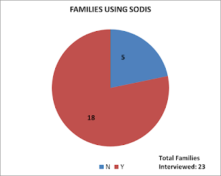
 To further investigate the probably of using the shallow public wells a source, we
sampled six (wells): one each from Robert Osoteo and a two neighboring houses (as
a baseline) and three wells used for irrigation. The samples were dropped off at the
Department Of Science and Technology (DOST) in San Fernando on the morning we
sampled (November 5). DOST is limited to testing of fecal coliform and was
unable to test for other important parameters such as pesticides, turbidity,
and TDS among others. We are working to
find the proper authorities to test for those items.
After walking through the community, we believed there are
many more wells than what was shown on the Google Earth map. We concluded that an
inventory/survey of the total number of houses and wells may be needed to get a
better grasp on feasibility of alternative water distribution design options. To use time efficiently in reaching out to
all seven sectors of the community, the four of us separated into two teams
(Walt/Steve, Bob/Anne) bringing along an interpreter for each team. The
community survey focused on the source(s) of water for each household, and disposal
locations of waste and grey water (important for examining potential
groundwater contamination).


 The second team of Stephanie Cook and Tiffini Smith arrived
in Apatut on November 5, in hopes of addressing other issues such: tapping into
the Province’s water main along the highway (household costs is a concern); status
of the Water Cooperative (formed in 2010, is it still active?); investigation of
the spring (in our survey, many households in Sector 4 admitted use for
non-potable applications); additional well sampling for specific water quality
parameters; and evaluation of a separate system for the elementary school.